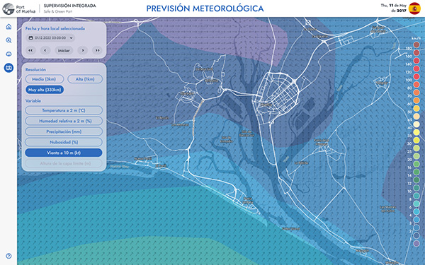
Environment and Weather Monitoring
Solution Group
Industry
PoC Duration
Iotellect Match
Accomplish early disaster warnings, improved public safety, better emergency response, climate change research, agricultural efficiency, energy management, environmental protection, increased public awareness, economic savings, and enhanced infrastructure planning. Plan and deliver your unique environment monitoring solution.
Iotellect is a low code IoT/IIoT development platform. It does not work as an out-of-the-box solution or product. Instead, it helps you to monetize your IoT know-how by dramatically lowering labor costs and cutting time-to-market for your product, service, or solution. It allows business-oriented IoT professionals to join the development process by converting their IoT market knowledge directly into product features and specific value delivered to your end customers.
Build Your IoT Application
Connect Your
Environment and Weather Monitoring Devices
Connectivity & Management
Integration
Analytics
UI/UX
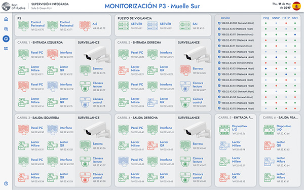
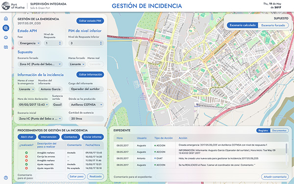
- Live tracking of environmental conditions and weather patterns through dashboards, maps, and heatmaps
- Visualization of data trends, including charts, graphs, and reports to support decision-making
- Representations of data intensity, such as temperature or pollution levels, across geographic areas
- Ability of users to interact with data points, zoom in/out on maps, and access detailed information by clicking on specific elements
Key Features for Your
Environment and Weather Monitoring System
Customers and Partners
- System Integrators
- Small or Medium Businesses
- Original Device Manufacturers
- Independent Software Vendors
- Government Agencies
Solution Users and Developers
- Dedicated low code developers
- Weather and environment experts
Assistance
Integrated Sea Port Supervision